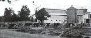
Historically, most major cities had a “dairy belt,” a rural zone far enough away where cows could be raised inexpensively, but close enough so that milk could be delivered fresh.
In the 1700s and early 1800s, New Orleans’ dairy production, as well as poultry and vegetables, came from nearby farmsteads along the Bayou Road and Metairie and Gentilly ridges, or from nearby plantations.
Well into the 1900s, truck farms with dairies operated on the urban outskirts, in places like Kenner, Algiers, Marrero and in St. Bernard Parish.
But by then, New Orleans’ main dairy belt had shifted to the Florida Parishes across Lake Pontchartrain, specifically Washington, St. Helena, and most of all, Tangipahoa Parish.
What brought dairy to this region was the construction of New Orleans’ first interstate railroad, followed by a clever railroad marketing strategy.
In 1851, investors formed the New Orleans, Jackson & Great Northern Railroad, aiming to connect with Mississippi by laying tracks across the Manchac land bridge into what were then Livingston and St. Helena parishes.
Four years later, the N.O. J. & G.N. opened for service, and its stations gave rise to the communities of Ponchatoula, Hammond, Tickfaw and Tangipahoa.
A parish is born
Despite damage during the Civil War, the N.O. J. & G.N. proved so effective in peopling this region that it helped justify the creation of Tangipahoa Parish in 1869, carved from lands of the four adjacent parishes.
What the railroad did from an economic perspective was enable shippers to send cargo in a fraction of the time taken by wagons or waterborne transportation. The parishes on either side of Lake Pontchartrain began to integrate into one regional economy.
Other railroads followed suit. The New Orleans & Northeastern opened a line to Slidell and Pearl River in 1883, from which spur lines were built westward to Abita Springs in 1887, to Covington in 1888, to Mandeville in 1892, and to Franklinton in 1907.
One could now wake up in New Orleans, board a train at sunrise, spend the day “across the lake,” and be home for dinner. Likewise, a farmer could now ship produce over 60 miles and have it arrive fresh at city markets.
That was particularly attractive for local dairy farmers, who could now graze their milk cows on cheaper land further out. They would soon be joined by farmers from the dairy belt of the nation: the Midwest.
Regional lines are taken over
In 1878, the Chicago-based Illinois Central Railroad Company took over the N.O. J. & G.N., part of a national trend in which larger companies subsumed smaller regional lines into their systems.
The Southern Pacific, for example, had recently taken over lines in southwestern Louisiana. Mulling ways to increase business, the company in 1883 began to recruit Midwestern farmers to cultivate rice. What better way to drum up ticket sales than to populate this rural prairie region with future passengers producing future freight?
In 1885, Illinois Central adopted a similar strategy. Looking to invigorate business between its new Southern stations and the Midwest (also called the “Northwest” in this era), the company designated Tangipahoa Parish as a “land point,” meaning a destination “to be advertised throughout the Northwest as having some special attractions in the way of good climate, cheap lands, nearness to New Orleans, etc., and to which point home seekers’ tickets would be sold monthly from all Illinois Central points north of the Ohio River.”
Illinois Central readied its largest station in Tangipahoa Parish for the newcomers, and used an aptly named planning firm to do it. In 1887, company officials persuaded a local landowner to sell property so that the Iowa and Louisiana Land and Lot Company could begin laying out part of what is now downtown Hammond.
For a generation to come, the Illinois Central Passenger Department employed a “general immigration agent” named J.F. Merry, based in Iowa, to work with Tangipahoa Parish, using Hammond as the “land point” in arranging ticket sales and property deals.
Combined with regional resettlement, the strategy helped triple Tangipahoa Parish’s population, from 9600 residents in 1880 to nearly 30,000 by 1910.
That Midwestern ambience
The effort imparted Midwestern farming culture into Louisiana’s piney woods, as well as a certain Midwestern ambience to the growing city of Hammond.
Farmers found the area to be well situated for dairies—not too close to New Orleans, and not too far. They could also raise strawberries, other fruit, vegetables, corn, oats and poultry for the urban marketplace, all but a couple of hours away by train.
Working alongside locally born farmers as well as immigrants from Sicily and later Hungary, the Midwesterners augmented the agricultural production of the region. The railroad strategy was a success.
Wrote one contented transplant from Peoria, Illinois, in a 1903 letter republished in 1989 by C. Howard Nichols, “Nine years ago this fall we moved to Hammond, Louisiana, where I have been engaged in gardening, fruit culture and dairying, receiving reasonable compensation for my efforts. Our climate is second to none … we like it here; the North has lost its attractions.”
“I came from Nebraska to Hammond in 1893,” wrote another; “I am engaged in dairying, in which I am doing well … I can raise more milk than I can sell. With this interest growing and the railroad giving us better facilities, it will be the richest crop that we have.”
The railroad sprouted additional station-based communities up and down Tangipahoa Parish. Midway between Hammond and Tickfaw, for example, arose Natalbany; halfway between Tickfaw and Amite formed Independence; between Amite and Tangipahoa emerged Roseland, Arcola and Fluker; and midway between Tangipahoa and Osyka in Mississippi formed the community of Kentwood.
Hungarian Settlement formed
Just west of Hammond, Hungarian immigrants arrived to work at the sawmill in Albany, many of whom later became farmers, forming today’s Hungarian Settlement in Livingston Parish.
Wrote J. F. Merry in 1910, Independence went from a mere “siding in the pine woods” in 1885 to a town of 1,200 people, amid 4,000 acres producing 282 carloads of strawberries per year, thanks to Midwestern transplants and Sicilian immigrants, among others.
Kentwood, “not on the map in 1885, now claims a population of 4,000,” with budding potential for “dairying, strawberry growing and truck farming.”
In 1910, Tangipahoa Parish shipped 2,000 gallons of milk per day to New Orleans, along with a daily average of 1.6 carloads of strawberries and vegetables.
In the decades ahead, greater New Orleans’ dairy belt grew in number of dairies, size, and spatial extent, expanding its production area into southern Mississippi and its consumption area from Baton Rouge to Biloxi and beyond. Stations along the IC were equipped with special cooling stations to keep the milk cold on its trek across the swamps.
The industry boomed statewide. Louisiana had 314,000 milk cows in 1940, more than one for every eight people, and most grazed in the dairy belt parishes.
Dairies in decline
In the 1950s, however, the number of Louisiana dairies began to decrease, while their average size increased. By the 1970s, both the number and the total production of Louisiana dairies began to decrease.
Refrigerated trucks travelling cross-country on high-speed interstates now put major national dairies within reach of most metropolitan markets, and regional dairy belts went into decline.
By 1987, Louisiana was down to 1,581 dairy farms and 83,381 milk cows, one for every 52 people.
The decline steepened. Costs rose, but revenue did not, due in part to federally set prices, while national competition and corporate consolidation put small regional producers at a severe disadvantage. Farmers’ children opted for other careers, and Louisiana dairy farms closed by the hundreds.
By 2017, only 132 dairies and 12,328 milk cows remained, one for every 372 Louisianians.
Tangipahoa still has a disproportionate share, with 4,958 milk cows on 45 dairy farms, as does Washington, with 4,618 cows on 34 dairies. Together they earned $26 million in 2017—still a multi-million dollar industry, and still comprising a dairy belt, but nothing like it once was.
In testimony to the struggling yet enduring geography of milk production, Brown’s Dairy, a major processor to which producers had shipped their raw milk since 1904, closed its downtown New Orleans facilities in 2016.
But Brown’s relocated to a familiar place—Hammond, the historic heart of the dairy belt. Inspectors from the State of Louisiana’s Milk and Dairy Unit are still mostly based in the vicinity.
Enduring legacy
The circa-1855 railroad corridor that gave rise to the dairy belt, meanwhile, also has an enduring legacy.
Still operated by Illinois Central, its right-of-way paved the way for Highway 51, and later Interstate 55, to be built in parallel. Each artery has brought economic activity to the old train-station towns, from Ponchatoula to Kentwood.
Tangipahoa Parish’s shape, too, testifies to the railroad’s importance, being elongated in the same orientation of the track bed—a peculiarity among Louisiana’s 64 parishes.
Midwestern-influenced agriculture has also affected local traditions. While there is no Dairy Festival in the dairy belt, Ponchatoula celebrates its Strawberry Festival every April, while Independence has a Sicilian Heritage Festival in March, for the many Italian immigrants who became farmers. The Washington Parish Free Fair in October features dairy cows among its many agricultural exhibits.
And remember that similar Southern Pacific strategy to recruit Midwesterners to southwestern Louisiana?
That policy explains why there is a town named Iowa near Lake Charles, why nearby Vinton was named for a city in Iowa, and why many historic structures in Jennings (nicknamed “Iowa Colony”) are what the late LSU geographer Fred Kniffen called “I-houses”—designs typical of Indiana, Illinois, and Iowa.
Richard Campanella, a geographer with the Tulane School of Architecture, is the author of “Draining New Orleans; “The West Bank of Greater New Orleans,” “Bienville’s Dilemma,” and “Bourbon Street: A History.” Campanella may be reached at http://richcampanella.com, rcampane@tulane.edu, or @nolacampanella on Twitter.


Leave a Reply