Overview
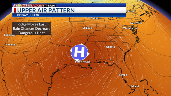
An upper-level ridge of high pressure over Texas is bringing a wide swath of hot temperatures across the Southern U.S. At the surface, high pressure in the Gulf is providing southwesterly winds in place over the region to keep moisture, and therefore higher humidity, in place.
The ridge will move to the east and be centered over the Lower Mississippi Valley by Thursday. These ridges promote large scale sinking motion underneath, which tends to suppress any rain chances. This will help temperatures continue to be elevated with highs in the mid-to-upper 90s and even lower 100s.
Factor in the higher humidity, (dewpoints are in the mid-to-upper 70s) and the heat index values soar past 100°F in excess of 110°F in most places. An excessive heat warning is in place for Wednesday over much of the Lower Mississippi Valley with heat index values topping out near 118°F.
Rain chances over Southeast Louisiana will remain limited near zero through the week. By Sunday into the new workweek, the ridge begins to flatten out and shifts over Florida. This will help allow the pattern to be closer to typical summertime conditions with highs backing off a few degrees into the mid-to-upper 90s. The chance for summertime pop-up showers and storms will return to the forecast by then as well.
Alerts
An Excessive Heat Warning is in place Wednesday from 10 am to 8 pm. High temperatures will be in the upper 90s flirting with triple digits under mostly sunny skies. The heat index values will be in excess of 110°F up to 118°F possibly.

An Excessive Heat Watch is in effect for the day on Thursday. High temperatures will be in the upper 90s and lower 100s possibly under mostly sunny skies. Heat index values will once again be greater than 110° up to 116° possibly.

Beat the Heat
First and foremost, it is extremely important to stay hydrated. Drink water even if you are not thirsty. It is best to avoid alcohol because it will dehydrate you further. Drinks with electrolytes will help you, as well.
Avoid strenuous activities outside between 10 AM and 6 PM, if possible. If you are working outdoors, make sure to take frequent breaks in the shade or where there is air conditioning.
Listen to your body and know the signs and symptoms of heat-related illnesses such as heat exhaustion and heat stroke.

Do not forget about your pets! Never leave them in an unattended vehicle – even if it is for 5 minutes. Keep walks brief between 10 AM – 4 PM and avoid concrete and asphalt.
For more information on heat and heat safety
Stay Connected
For the latest forecast information, check out our weather page!
Remember that you can download our weather app. It’s available to download now in the App Store and Google Play. Just search for “BR Proud Weather”.
You can receive weather and lightning alerts if lightning has been detected within 15 miles of your location.
Be sure to follow the StormTracker Weather Team:


Leave a Reply