

Overview
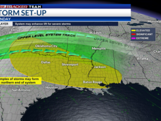
A stalled frontal boundary continues to leave portions of the Southern Plains and the South under an unsettled and active weather pattern. Meanwhile in the upper-levels of the atmosphere, there is a stout ridge of high pressure over southern Texas and northern Mexico. Along the outside edge of the ridge lies the Greater Baton Rouge area. Upper-level disturbances are riding along the outside edge of the ridge, which has led to a couple of storm complexes to nearly clip our area – this is still a possibility that these storms clip our northern parishes and Southwest Mississippi counties on Thursday and Friday. In turn, the Storm Prediction Center has placed areas along and north of the I-10/I-12 under a Marginal Risk (threat level 1 of 5) for severe weather. Most, if not all areas, will get through without any storm issues. The same ridge of high pressure will slowly expand east and the frontal boundary will lift northward, which means our rain chances will drop and temperatures will go up. Record high temperatures, along with very high humidity will lead to dangerous conditions through the weekend and into next week.

Alerts
A Heat Advisory is in effect from 11 AM through 7 PM on Thursday. High temperatures are expected to be in the mid and upper 90s, but the high humidity will make it feel like 105-110 degrees; However, it will feel even hotter in the direct sun.
Additional heat alerts, such Heat Advisories, Heat Watches/Warnings, are expected over the weekend and potentially into next week. Temperatures are expected to climb into the upper 90s to potentially the lower 100s, but heat index values will be between 108-115 degrees. This kind of heat and humidity can and will lead to heat-related illnesses if proper precautions are not taken!
Overnight temperatures in the 70s and 80s will not provide much relief, considering it will still be extremely humid and warm.
For the latest forecast information, check out our weather page!


Beat the Heat
First and foremost, it is extremely important to stay hydrated. Drink water even if you are not thirsty. It is best to avoid alcohol because it will dehydrate you further. Drinks with electrolytes will help you, as well.
Avoid strenuous activities outside between 10 AM and 6 PM, if possible. If you are working outdoors, make sure to take frequent breaks in the shade or where there is air conditioning.
Listen to your body and know the signs and symptoms of heat-related illnesses.
Do not forget about your pets! Never leave them in an unattended vehicle – even if it is for 5 minutes. Keep walks brief between 10 AM – 4 PM and avoid concrete and asphalt.
For more information on heat and heat safety


Stay Connected
For the latest forecast information, check out our weather page!
Remember that you can download our weather app. It’s available to download now in the App Store and Google Play. Just search for “BR Proud Weather”.
You can receive weather and lightning alerts if lightning has been detected within 15 miles of your location.
Be sure to follow the StormTracker Weather Team:
Leave a Reply