

Overview
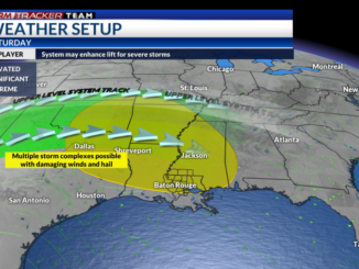
An incoming upper-level system, as well as a frontal boundary, will trigger a complex of showers and storms near the Texarkana and Northern Louisiana regions. This complex will move southeastwards towards Southern Mississippi and Southeastern Louisiana. As this complex progresses, daytime heating with highs in the mid 90s and increased moisture with dewpoints in the 70s will enhance instability, or fuel for storms, greatly over the region. This along with moderate upper-level winds will aid in the severe threat.
Potential Impacts and Timing
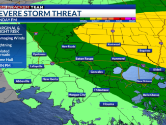
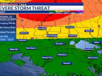
The Storm Prediction Center (SPC) has placed a slight risk (2/5) for areas near and north of the 10/12 corridor. Elsewhere is placed under a marginal risk (1/5).
Storms will have the potential to produce damaging winds and large hail. Even if the storms do not reach severe limits, storms may produce gusty wind, frequent lightning, hail, and downpours. Intense localized heavy rainfall could aid in producing isolated instances of minor flooding or ponding.

Keep an eye on the radar if you will be outdoors and make sure you have a safe place to go in case you need to seek shelter. Do not forget that lightning can strike 10+ miles away from its parent thunderstorm. If you hear thunder, you are close enough to be struck by lightning. Outside of storm chances, expect hot and humid conditions with highs in the mid 90s, but it will feel like the lower 100s. Make sure you stay cool and hydrated!
Stay Connected
For the latest forecast information, check out our weather page!
Remember that you can download our weather app. It’s available to download now in the App Store and Google Play. Just search for “BR Proud Weather”.
You can receive weather and lightning alerts if lightning has been detected within 15 miles of your location.

Be sure to follow the StormTracker Weather Team:
Leave a Reply