

Overview
A cold front will be moving through the Lower Mississippi Valley Friday through early Saturday morning. Showers and storms are expected to form ahead and along the front stretched from the Lower Ohio Valley into the Lower Mississippi Valley. Storms will have the potential to turn strong to severe with all hazards at play.
The greatest risk (but not the only risk area) for severe storms will an areas around the ArkLaMiss region where widespread severe storms are possible with a strong tornado potential.
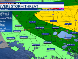
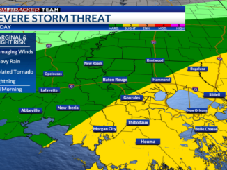
Over our area in Southeast Louisiana and Southwest Mississippi, isolated to scattered strong and severe storms are a possibility. The risk becomes greater the more north you go. With that, the Storm Prediction Center (SPC) has placed areas south of the 10/12 corridor under a Marginal Risk (1/5), north of the interstates in a Slight Risk (2/5), and portions of the Florida Parishes and our Southwest Mississippi counties under an Enhanced Risk (3/5).
Threats: All threats will be at play for any storm that strengthens to severe limits. The main concern for our area will be damaging wind gusts (58+ mph) and a few tornadoes. Some hail will remain possible with a stronger storm. Flooding rainfall is not a large threat, but there is a potential for locally heavy downpours that could lead to ponding. Localized flash flooding could be an issue for the northernmost areas, but overall rain totals are expected to be under an inch.

The tornado threat will be greatest in the area of Moderate Risk (4/5). There is the potential for strong and long tracked tornadoes in the hatched region below. The tornado threat begins to decrease the further south.

Timing: Scattered showers and a few storms will begin to develop ahead of the front during the afternoon around 2-5pm. The frontal boundary will begin to push into the area with the rest of the rain and storm potential into the night around 8pm-2am.


Discussion
An upper-level shortwave trough will eject from the Southern Plains Friday into Saturday which will promote surface cyclogenesis. This center of low pressure will be moving northeastwards across northern Arkansas through the Mississippi Valley Friday night into Saturday morning. A cold front will be stretched southwestward from the low.
As the cold front progresses eastward with time, showers and storms will fire up ahead of and along the frontal boundary early Friday afternoon near the Louisiana/Texas border and ongoing storms will be moving into Arkansas. Some areas of showers and storms will develop near and north of the Florida parishes ahead of the front before the rest of rain continues to move eastward Friday night.

Let’s discuss the severe aspect of this system. Off the bat, SPC has placed a Moderate Risk (4/5) to our north, where there is the greatest risk for discrete supercells in the open warm sector and the potential for strong tornadoes. Over the Baton Rouge area is a Slight Risk (2/5) and a Marginal Risk (1/5) south of the interstates.
Warm and moist air will not be a problem with onshore winds from the south as temperatures reach into the mid 80s during the afternoon and into the mid-to-upper 70s during the evening. Dewpoints in the mid-to-upper 60s will stretch as far north into Tennessee in the warm sector. With that, instability will be ample as CAPE is around 800-1400 J/kg. Some of that instability decreases overnight as we lose daytime heating.

The first issue will be shear over our area. Winds at the surface become southwesterly later Friday, which becomes closer to the direction of the upper flow. So, directional shear will be very limited but speed shear will exist – This will put a limit on the tornado potential since rotating updrafts will have a difficult time forming.
The next problem will be the synoptic forcing for storms to fire up from. The surface low is a touch too far north along with the shortwave. Geopotential height falls and upper-level diffluence are greatest over the ArkLaMiss region. This forcing is pretty lackluster over Southeast Louisiana; therefore, storms may have a hard time forming and becoming robust. Some storms may develop near the east/west Louisiana/Mississippi state line. As they track to the north, they will be moving into a more favorable environment where they have a better chance at becoming severe.
So, with all of this, severe storms are possible over our area, but they will have a hard time materializing. With the lack of forcing as the actual cold front pushes east towards the night, a broken line of scattered showers and a few storms will move through. Even though rain and severe storms will be possible, there is a chance most neighborhoods will not see any impacts. The potential for severe impacts increases the more north you go.
How to Prepare
Be sure to multiple ways to receive weather alerts and stay tuned to updated forecasts during the day. Make sure your phone is unmuted, charged, and turned on for WEA notifications.
Have a plan and a safe place to go to if a warning is issued for your location. Find a lower-level, interior room away from windows. Secure outdoor furniture and decor beforehand.
You can always check out the Interactive Radar here.
For the latest forecast information, check out our weather page!
Remember that you can download our weather app. It’s available to download now in the App Store and Google Play. Just search for “BR Proud Weather”.
Be sure to follow the StormTracker Weather Team:
Chief Meteorologist Ashley Ruiz – Twitter | Facebook
Leave a Reply