

Overview
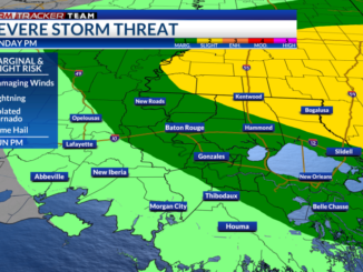
A strong cold front will be moving in from the northwest overnight Thursday into Friday morning. A line of scattered showers and storms, some of which could be strong to severe, will be associated with this front with as it moves across the South. The Storm Prediction Center (SPC) has placed most of our viewing are under a marginal risk (1/5) and southeast portions under a slight risk (2/5).
This front could cause issues with your Friday morning commute with gusty winds and heavy rainfall. Colder temperatures return after the front with highs in the 50s and lows in the lower 40s for the weekend.
Threats: This front will take on a squall line form with damaging wind gusts being the biggest concern. Damaging wind gusts of 58+ mph will be possible with the stronger storms. Another main concern will be the heavy rainfall threat. Rain will linger after the leading edge with reasonable totals around 1-2″ with locally higher amounts. There is a marginal risk (1/4) for excessive rainfall over the area. Localized areas of flash flooding could occur.


There is a non-zero chance of a brief, isolated tornado being embedded in the line, but the threat is not too high. Hail does not look to be a threat for our areas with these storms.

Timing: The leading edge of showers and storms will begin to enter our northwestern areas before daybreak and continue towards the Baton Rouge metro around 7-10am. This could cause concerns for Friday morning commutes. Even after the leading edge clears, the severe threats lowers, but rain and a few elevated storms will continue into the afternoon and evening. Some guidance shows some isolated areas of light rain lingering overnight into early Saturday morning.


How to Prepare
Be sure to multiple ways to receive weather alerts and stay tuned to updated forecasts during the day. Make sure your phone is unmuted, charged, and turned on for WEA notifications.
Have a plan and a safe place to go to if a warning is issued for your location. Find a lower-level, interior room away from windows. Secure outdoor furniture and decor beforehand.
You can always check out the Interactive Radar here.
For the latest forecast information, check out our weather page!
Remember that you can download our weather app. It’s available to download now in the App Store and Google Play. Just search for “BR Proud Weather”.
Be sure to follow the StormTracker Weather Team:
Chief Meteorologist Ashley Ruiz – Twitter | Facebook
Leave a Reply